You need to be careful flying through the Colorado Rocky Mountains in a small non-turbocharged plane, but it can still be done safely. There are many paths over the Rockies. What path to use depends on each particular situation: clouds, winds, weather, and intended direction. Also what you are comfortable with and your experience. In general, I do not pick straight lines, but instead follow the main valleys and minimize my time flying over the highest mountains. Through my trips west, I have used quite a few paths. Each one is quite beautiful.
Here are the main paths I have taken crossing the divide going from the furthest north to the furthest south. All these routes are not exact, but approximate. The flight path tool I could find could not show the route more exactly.
One interesting item to note is that the section from Grand Junction along the Colorado River to Vail and to Kremmling is very well covered by radar almost to the ground. This makes flight following possible and a good idea. All the other routes (through Gunnison and Alamosa) are not covered well by radar at lower altitudes.
North route into Southern Wyoming and westUsually only needed if heading somewhere further north. This is the lowest terrain on the North side of the Colorado Rockies.
klmo-kfnl-klar-ckw-ocs-fbrOver Colorado/Wyoming border, to Kremmling, and along the Colorado River A nice low spot exists near the CO/WY border. Below is the route, but I would not go all the way to Laramie. This is the closest I could indicate on this flight planning tool.
klmo-kfnl-klar-k33v-rlg-kege-kgws-kril-kgjtI hear going over Cameron Pass or the FROGS intersection can be good. I have not had the situation yet where I used it for long trips, but I have gone over it for fun though.
Over Rocky Mountain National Park and along the Colorado RiverGoing over Rocky Mountain National Park is often less bumpy than over Corona pass.
klmo-allan-rlg-kege-kgws-kril-kgjtOver Rollins Pass (Corona Pass) and along Colorado Riverklmo-kbjc-rlg-kege-kgws-kril-kgjtSouthern Middle Route through Salida then GunnisonA nice middle route if the norther routes will not work. There are 2 ways to get to Salida:
klmo-larks-kank- through Wilkerson Pass and Salida
klmo-pub-kank- through Pueblo then Salida
Then through Marshall pass (better than Monarch pass since Monarch is a sequence of ridges with downdrafts instead of just one)
- CO11-hbu-kmtj Southern route through Alamosa and DurangoAnother route further south if the main mountain section is bad for weather. There are three ways to get to Alamosa:
klmo-larks-kank-als- through Wilkerson Pass and Salida then Alamosa
klmo-pub-kank-als- through Pueblo then Salida then Alamosa
klmo-pub-gosip-als- through La Veta Pass then Alamosa (La Veta Pass can have some pretty big turbulence for being a low pass)
Then through Durango
- brazo-droVery Southern route near AlbuquerqueOn the way back to Longmont in the past, I have had to wait in Albuquerque for a snow to clear in the Denver area. Then I proceeded the rest of the way when the snow cleared. This is the lowest terrain route on the southern side of the Colorado Rockies.
kabq-nelge-lvs-pub-klmoAnother route for the north/south portion that has had less turbulence for me is on the windward side of the Sangre De Cristo mounains.
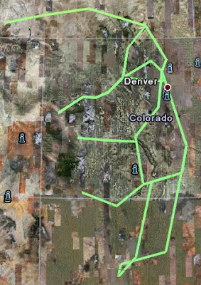
Combined Picture of Routes
Using the above flyagogo links, then clicking on the little Google earth button on the left side of the web page for each link, I built a Google Earth image with all the routes. (Save the file and load it into Google Earth). If you want you can add the sectionals by clicking on this link to Google Earth Sectional Chart information. If you are zoomed out, I think the sectionals do not look good. But zoomed in, the sectional information is nice. I found these addons for NexRad Information for Google Earth, West Cloud Satellite information for Google Earth, and Eastern Cloud Satellite information for Google Earth.
Some Quick General Thoughts
Take a mountain flying course. Many instructors in Denver area are available for this type of instruction.
Landing in the moutains is different; here are some of the factors:
- Density altitude is a major factor.
- Your ground speed will be higher since you are flying the same indicated approach airspeed at a higher altitude.
- Short field methods are important even on longer strips.
- Your horizon and determining what is straight and level is sometimes confusing since the sky horizon is much higher than the real horizon.
- Your approach and pattern is often restricted by high moutains.
- Many other items that you would cover in a mountain lesson.
Colorado Department of Transportation has a nice book and on-line information for all the different Colorado airports.
Approach ridges at 45 degrees to reduce the amount needed to turn around if needed. Watch out for downdrafts and turbulence. Don't fly over the ridges if the winds aloft are expected to be above 30 knots at 12,000 MSL. Always have an out if something goes wrong. And IFR over the rocky moutains is a bad idea in small planes; don't try.
There are many AWOS stations near passes. Use this information where you can. It can give you an idea of how the winds are doing in different places.
Here are some books to read available at Marv Golden. Sparky Imeson has a good website with lots of mountain flying information.
Once again take instruction if at all possible.
/Brian